


the world is changing...
Knowing where and how allows us to make an impact!
Climate change, wildfires, floods, extreme storms, tropical cyclones, desertification, environmental degradation, heatwaves, drought, seasonal shifts and an exposed population - knowing the risk is the first step

Climate Change

Disaster Risk

Spatial analysis
... is by it’s very nature a complex field. The work I undertake is rooted in robust analysis, but is presented and explained in a way that is actionable to the decision maker or the “man on the street”. This is done by contextualizing climate concepts to real world experiences to which non-climatologists can relate and that are easily understood. Current research is focused on more efficient automated analysis so more time can be spent to unpacking the impacts in practical ways.
... seeks to highlight the current and potentially likely hazards, vulnerability and capacities that contribute to the cumulative risk of an area or towards a sector. This is done though a combination of several indicators of risk as well as historical hazard occurrence. I’m currently developing new methodologies seeking to fill the gaps in data where hazard records are substandard though the classification and highlighting areas exhibiting particular risk signatures/attributes.
... is often what people first relate to. When we are able to orientate themselves relative to the data or analysis presented, the information becomes real. Working in the GIS field one should relate multifaceted data, accurately into an intuitive spatial interface though customized information design, highlighting locally specific focus areas in the context analysis. Furthermore, simplified spatial portals and all-in-one dynamic data dashboards and real-time spatial analysis will effectively empowering decisionmakers
My work
As a professionally registered Natural Scientist specialising in Climate Change (SACNASP), Disaster Management Associate (DMISA), and Geomatics Professional (SAGC) my work focuses the spatial distribution and statistical implications future climate changes, predominately from a climate exposure/disaster risk mitigation perspective.
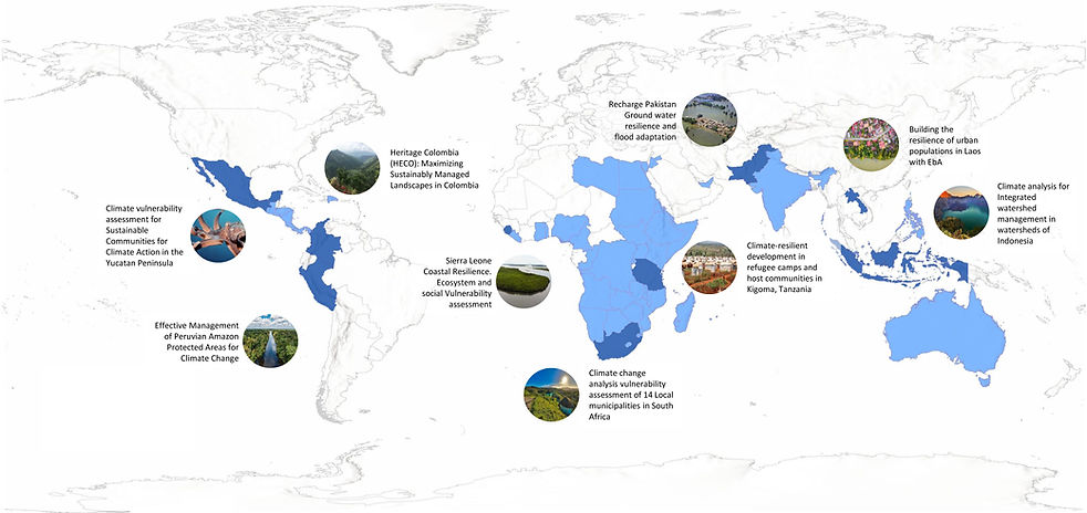
I’ve been privileged enough to work on some amazing projects impacting many tens of thousands of the most vulnerable people. I’ve worked of projects ranging from Early Warning Systems (EWS) in Sudan to climate exposure and environmental degradation in Refugee camps and host communities in Tanzania, to climate implications for mining operations in Nigeria, climate risk to the property sector in Australia, the suitability of a solar farm in Namibia, and the siting of water distribution points during the Day Zero planning in South Africa.
In all my time working, I’ve sought for my work to be more than a report gathering dust. Unfortunately, these critical concepts are among the most poorly understood by most. I have therefore sought to appreciate what is needed, what the barrier to entry into the climate/disaster risk implementation may be, and adapt the information delivery to both be comprehensive and stand up to academic scrutiny, and also being approachable and actionable by policymakers, practitioners and decision-makers.
Projects have been undertaken around the world, with a strong focus on the more vulnerable developing world of Africa, Central America, Australasia, and Southern Asia. The various services rendered in these projects include bespoke climate analysis, vulnerability and risk assessments, data gathering and presentation, disaster risk management, business continuity, stakeholder engagement and training, local appraisals, and spatial analysis. Project experience and flagship projects are shown below.


Climate Change Analysis
This includes spatial and statistical analysis of future Representative Concentration Pathway (RCP) scenarios to get a better idea of the future meteorologically. Each area is different with varying objectives so the analysis is customised but will include some of Spatial analysis and mapping, Regression, Trend, confidence, significance testing of long term annual and decadal change. Variance and standard deviation testing determining the year on variability and climate reliability, threshold analysis such as dry spell duration or days over 35°C. Analysis can also include more contextual assessment including temperature and rainfall profile changes, monthly/seasonal anomalies, rainfall onset and cessation times. Lastly the assessment of current and projected extreme events such as flooding or heatwaves
Analysis techniques are consistently being improved and adapted and I’m open to undertaking expanding to suit the needs of the project.


Clients
Working Together
I've been lucky enough to work with some amazing clients designing climate and disaster risk solutions in my career. Through some of these projects, we’ve made a difference to tens of thousands of the most exposed people.


A Little About Me
I’ve been working in climate, disaster risk and spatial analysis for 12+ years. I started at the bottom doing spatial data capture but over time my passion for climate analysis, mapping and disaster risk mitigation took the focus. I’ve worked in both large multi-nationals and smaller consulting firms. Both had benefits, such as working with brilliant people that added so much more to my understanding, but there were also some limitations that I thought would be lifted with a strategic shift in priorities. To this end, I’ve started independent contracting allowing me more flexibility to deliver the project that the client needs, but also one that doesn’t sit on a shelf gathering dust.